| OGSR Wireline By OGSR Library August 2022 |
Hi , Welcome to the third quarterly edition of OGSR Wireline in 2022. This edition comes a little later in the year so we have an opportunity to provide
updates on all the major things happening in the summer months. Library users will be especially interested in the complete virtual conference proceedings for EPEX 2022, now available. Significant updates in GIS, geology, and of course the monthly drilling report can all be found below, enjoy! Major updates are underway on the website, most importantly our digital data has been updated. The new licence list now shows the history of all new licences issued in the past two years.
Changes and improvements will continue behind the scenes for now but the big update is coming. All the best, OGSR Library Team Jordan, Matt, Ramen, Connor, Zohreh, Lorraine |
EPEX Media Update by Matt and Zohreh | |
EPEX 2022 Videos Now Available By Matt and Zohreh EPEX 2022 took place on May 31. It was great to get together in person for the first time
since 2019. OPI’s 59th annual conference was offered as a hybrid conference, meaning it took place in person at the Ramada by Wyndham Hotel in London as well as virtually over Zoom. Presentations also followed this hybrid model with some that were pre-recorded over Zoom and others that were delivered in person on the day. Miss the conference or want to revisit a presentation? All of the pre-recorded talks are now available on our YouTube channel. The presentations recorded live on the day are currently being edited and will appear on our YouTube channel every other week. The next video will be Cam Baker’s presentation Flowing Wells in the Big Creek Valley, Norfolk County – History, Conditions and Remediation Options. Looking good in VR We’re proud to announce that
the OGSR Library has a new camera for virtual reality filming! The Canon R5C, when paired with the new dual fish-eye lens, will produce extremely sharp video for Virtual Reality in the 180-degree format, in 3D. Capable of capturing video in 8K at 60 frames per second, this is going to be a huge bump in quality from our previous equipment, which offered 3D 180 in 5.7K at 30 frames per second. The extra frames per second will eliminate a lot of the motion blur that contributes to the motion
sickness some people experience in VR. Video will be crystal clear with tonnes of fine detail. Cutting edge stuff!
Look for our VR series on the Lockport group to be posted soon. One of these videos is a virtual core workshop that will examine the formations included in the Lockport Group in detail. Our own Zoreh Ghorbani, has written the script and I’ll
let her describe the video further. Zoreh: The OGS VR core workshop is a scientific-based tour about the lithostratigraphic characteristics of the Lockport Group. In this video, an introduction to the age, geography, geology, and resource potential of
Lockport rocks using real-world or model clips was provided. In the core workshop, the lithological features of Gasport, Goat Island, Eramosa, and Guelf formations of the Lockport Group strata along the outcrop-subcrop of the Niagara escarpments and the deeper subsurface of southwestern Ontario were described. Selected cores include stratigraphical sections, showing the depositional and karstic features. Finally, the factors controlling the fluid movement in the near-surface and in the
subsurface, including the topography and karstic sequence stratigraphic boundaries, were discussed. Thanks, Zoreh! We look forward to sharing this content with you soon. Finally, I just want to give a shoutout to Oil Museum of Canada. They have completed their
major renovation and the results are stunning. We’re very proud to have our first VR video, A First Look at Ontario’s Geology in VR, setup as an installation prominently featured upon entering the museum, quite the honour. Be sure to make the drive out to Oil Springs to check out all the hard work that’s been done (figure below).
GIS Team Update By Connor and
Connor
Hello everyone! I’m Connor Turnecliff, a GIS and Database Assistant with the OGSR Library this summer! I’m going into my third year of the Bachelor of Environmental Design and Planning program at Fanshawe College and have been working with the team at the
library since the end of April. In the past couple months, I have been working on multiple projects for the library and so far, it has been a really cool experience. As a student who doesn’t have a background in geology, it has been an amazing learning experience and every day I learn something new at the office! I have been helping the team with GIS projects such as creating maps for the EPEX Conference and MNRF reports, as well as creating templates to use for future custom map making. Another
project I have been working on is scanning the never before seen Sanford Ledgers which are handwritten documents of wells in Ontario dating from the early 20th century. Once finished, these ledgers will be available for library members to download and will provide interesting insights into the history of the Ontario oil and gas industry.
There have also been
lots of opportunities for me to learn about this field of work through various field trips we have gone on. The office took a day-trip to the Fairbank Oil Field and Oil Museum of Canada in Oil Springs which were amazing to see. I got to learn so much about the industry and was blown away by how much history Ontario has with oil and gas! We also visited Mystery Falls outside of Arkona, where I got to learn a lot from our geology staff and hunt for fossils. I've always wanted a brachiopod that
sits with me at my desk! I never knew Ontario was full of such interesting geology! Working at the library this summer has certainly been exciting and I look forward to finishing the rest of my work term with the team before I head back to school in the fall!
- Connor Turnecliff Hey, my name is Connor M. and I am a student of Honours Bachelors of Environmental Design and Planning at Fanshawe College. I have been working at the Oil, Gas & Salt Resources Library as a GIS & Database Assistant for just over two months now and we have been busy!
There are a lot of exciting projects going
on at the library right now and plenty of other events to take part in. Some tasks I’ve been working on this summer include scanning and entering geophysical logs, generating maps and data for the geology teams, and learning how to model for 3D printing. The 3D printing has been an especially interesting experience as it combines GIS and design elements in a new way that is challenging but rewarding. We haven’t been stuck in the office all season though. The library staff has taken field trips
to beautiful and fascinating locations such as Mystery Falls, Oil Springs, and the Oil Museum of Canada. A lot has already been completed, but there is always more to do. I will be looking forward to seeing what else gets accomplished in the second half of the summer.
- Connor MacLeod
Left: Historical oil and natural gas well ledgers and maps from the collection of GSC geologist B.V. Sanford. Right: Connor scanning the Sanford ledgers using the Library's large format scanner. Soon digital copies of these ledgers will be available on the Library
website. Geology QA/QC Knowledge Update By: Ramen Tolo and Elisa Dong For the past three months, the QA/QC Geology team has been working on two major projects. The first involves creating more content for the library and its
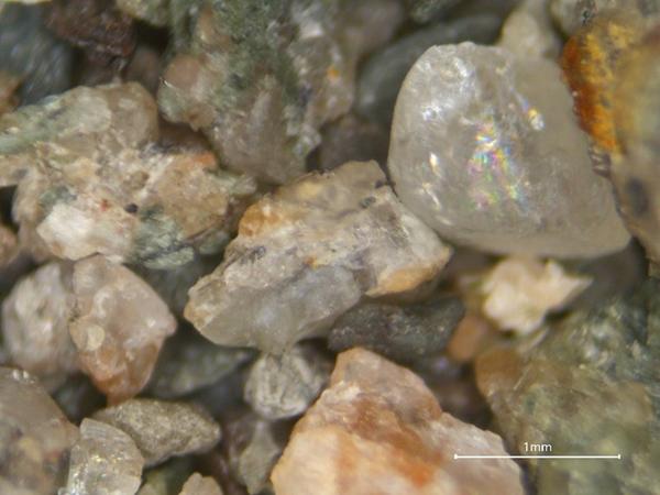
users to access. This involves increasing our core and drilling chip sample photographs. In total, we were able to take 8000 photos by end of July. The break down of these images includes 12 wells, where the chip samples were photographed (6899 vials) and 25 wells had the core photographed (1250 photos). The contents of the vails for the chip samples were photographed three times. Twice at zooms 10X and 30X, and another 10X to show the diversity of minerals in the sample (Fig 1). We also
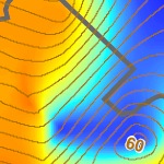
photographed cores of 25 wells (1250 photo). The core photos were taken on our custom stage and also in three modes to highlight core features in UVF lighting, DRY, and WET conditions (Fig 2). These images should now be available to the public via our PxTools which provides additional layers in Google Earth.
Our second project involves a review of the deep geology in southern Ontario. The geology team has been improving
on picking methods for several formations. To this end, we have been core logging wells and assessing the contents of relevant drilling chip samples to identify the characteristics of individual formations. In addition, we reference the digitized geophysical logs to consider the characteristics of formations where chip samples and core are not available. At this time, two cross-sections are being developed to show how these formations would connect stratigraphically and
geographically.
Some fun things! The geology team participated in trips planned by the OGSRL. We went to visit Mystery Falls to better improve our understanding of the geology of the region, and to view rocks and fossils. The grand prize for finding a trilobite still remains unclaimed. For our second trip, we visited Fairbank Oil Field and the Oil Museum of Canada to better understand the history of oil and oil production
in southern Ontario. The creaking of the jerker-lines made for a very peaceful scene in the pastoral landscape. As did the birds being rocked to sleep (Fig 3). One of the team stopped in at a work shop on the Canada Safety Standards to give a geology focused talk on salt mining in Ontario.
In other news, joining (and soon to be leaving) the team is our Summer Intern – Elisa Dong. She has greatly enjoyed her time working
at the OGSR Library on the QA/QA Geology team, and still thinks that the library could expand to include a metaphysical gift shop to make use of our salt cores, a café, and custom 3-D printing/embossing services.
Figure 1: An example of photographed chip sample vials Figure 2: An example photographed core in three modes UVF, DRY, and WET Figure 3: A bird enjoying a swing on the jerker link that powers several wells at Oil Springs. |
Monthly Drilling Report - July 2022 by OGSR Library Team |
New Licences Issued Licence No. | Issue Date | Operator | County | Township | Type/Class | Licence Depth
(m) | T012662 | 2022-07-06 | Ontario Power Generation Inc. | Durham | Lake Ontario | STR/STR | | T012663 | 2022-07-06 | Ontario Power Generation Inc. | Durham | Lake Ontario | STR/STR | | T012664 | 2022-07-06 | Ontario Power Generation Inc. | Durham | Lake Ontario | STR/STR | | T012665 | 2022-07-06 | Ontario Power Generation Inc. | Durham | Lake Ontario | STR/STR | | T012666 | 2022-07-14 | PRIVATE OPERATOR | Lincoln | Caistor | PGP/DEV | | T012667 | 2022-07-26 | Stelco Inc. | Haldimand | Walpole | OBS/OBS | | T012668 | 2022-07-27 | 1000073740 Ontario Inc. | Lambton | Enniskillen | OPGP/NPW | |
No New TD Reports New Licenses Issued for Existing Wells No New Licences Issued for Existing
Wells Plugged Wells No New Well Plugging Reports |
If you are having trouble viewing this newsletter, it can be viewed here.
What is the OGSR Library?
The Oil, Gas & Salt Resources Library is a not-for-profit corporation that manages all of Ontario's public drilling and production data from the petroleum and solution mined salt industries. This includes processing, storing, and providing safe and convenient access to all of the industry's drill core and rock cuttings. The Library makes as much of this data as possible available through our online portal to members all over the world. The financial support of the petroleum industry and
our membership make this possible.
|
|
|
|