|
| OGSR Wireline By OGSR Library October 2025
Edition |
Hi , Welcome to the fall edition of OGSR Wireline!
Inside you’ll find: - post-summer work updates
- details about the new 2025 Pools and Pipelines Map
- upgrades to our chip sample archive and photography catalogue
- our
latest video releases
- Monthly Drilling Report
- and more
Our team has been working diligently to deliver on our primary purpose: managing information relating to Ontario’s petroleum wells and subsurface fluids. Collecting, organizing, and
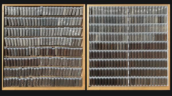
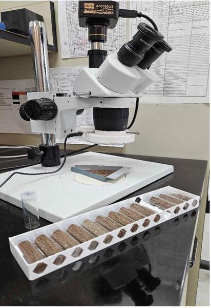
upgrading datasets is central to our mandate. It also includes capturing and sharing the knowledge needed to use those datasets, then promoting these resources so all users can benefit. On the collections side, the OGSR Library is pleased to introduce a new 3D-printed tray insert for chip sample vials. Printed in-house, the inserts provide non-rolling vial storage, stack neatly, hold vials facing
the viewer, and create a more organized experience so visitors can focus on the geology. We have also increased the number of rows per tray, extending the Library’s storage capacity. See Clodagh’s article below for details on this upgrade. Figure 1. Before and after adopting the new 3D-printed, non-rolling sample-tray inserts. On the knowledge management front, Matt has been preparing the EPEX videos, which preserve key industry knowledge, and most are now available online. He has also been filming geology across southern Ontario
in virtual reality so users can explore key sites remotely. In GIS, we have updated petroleum pool boundaries. Connor’s article outlines what's changed and how to use the layer in your projects. Staff have also been improving chip photography using several techniques. Brian and Melissa share the details
below, including tips for consistent labeling and clearer imagery. We invite you to read on for new developments in information management and knowledge management, and to catch up on industry trends in the Monthly Drilling Report.
All the best, OGSR Library Team Jordan, Matt, Connor,
Brian, Melissa, Clodagh, Lorraine |
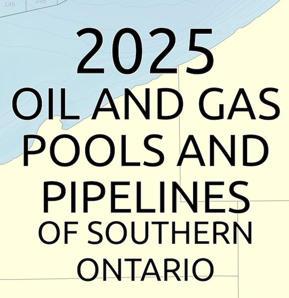
Pools and Pipelines Map New Edition by Connor |
Capturing the Cambrian for VR by Matt |
A Quarter of Progress by Clodagh |
UV Chip Photography by Brian |
Streamlining Chip Sample Photography by Melissa |
Monthly Drilling Report by OGSR Library |
Pools and Pipelines Map 2025 Edition by Connor |
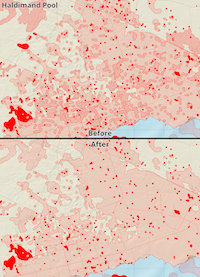
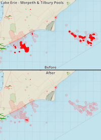
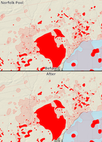
The 2025 Pools & Pipelines of Southwestern Ontario map is
now available! It contains updated pool boundaries, production values, and some exciting visual improvements including bathymetry and topographic overlays. Pool boundaries on the map are reviewed annually to reflect well status updates. Revisions are provided as yearly shapefiles, which can be downloaded from our website. Examples of these updates are shown below. |
Figure 1. Matt filming Sandstone Island, Charleston Lake Provincial Park. Capturing the Cambrian for VR by Matt |
Cambrian Age rocks are the hot topic in the Ontario
underground scene right now. They're being studied for carbon capture and storage, potential energy resources, and formations are currently being analyzed, resorted, and renamed. Much of the VR content we've been working on focuses on the Cambrian, but being in London these rocks are too far away for us to travel to and see in the wild. During a recent trip to Ottawa for the GAC-MAC conference, we were able to make a couple stops on the journey home to capture some Cambrian and Precambrian rocks
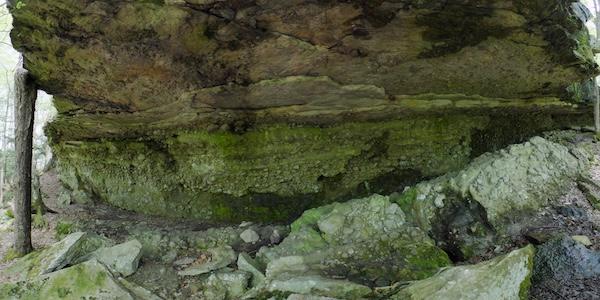
with our VR camera. Figure 2. Closer view of Sandstone Island featuring Cambrian on top, conglomerate in the middle eroded layer, and Precambrian below. Our main stop was in Charleston Lake Provincial Park, located off Highway 3 near Leeds Ontario and the Thousand Islands area. The park's Sandstone Trail
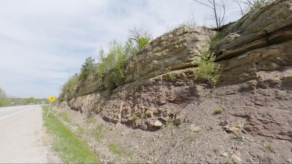
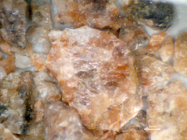
features Sandstone Island, a stunning geological feature that shows Cambrian rocks sitting on a layer of conglomerate, with Precambrian rocks underneath. The conglomerate has eroded much faster than the rock above and below, creating an above water Cambrian rock island. We captured an entire tour's worth of views of this feature for upcoming VR videos. We also passed by Elgin, Ontario and stopped on Highway 15 to capture an exciting outcrop that features both Precambrian and Cambrian rocks. The distinct combination of pink and grey hues of the bottom half really jumps out in the photo below, providing excellent contrast with the Cambrian rocks of the upper half. Study the rock
chip sample from a well approximately 100km away for comparison, provided below. Figure 3. Road cut on HWY 15, near Elgin, ON. Figure 4. Precambrian rock chip sample from T002621. Cambrian and Precambrian outcrops were key items missing from our archive of Ontario's geology for VR. These features are valuable additions to our growing archive of 3D assets of Ontario's geology. Having a complete archive of Ontario's geology for VR allows us to create content that goes from a chip sample under a microscope to a real outdoor example, connecting back to nature and opening learning pathways to understanding geological concepts. Some of our past trips to gather VR video of Ontario's geology include Mystery Falls and Rock Glen (Devonian Age), Elora Gorge (Silurian Age), and Niagara Glen (Silurian and Ordovician Ages). Adding the Cambrian and Precambrian to our archive gives us a more complete picture of Ontario's geology.
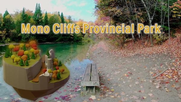
Combining rock cores, chip samples, 3D models, and real world examples can provide a better, more complete understanding of the rocks we stand on every day. Experience fall vibes from the comfort of your living room by revisiting our Monocliffs in VR video. Features a thorough series of closeups of the cliffs for
studying its weathered Silurian Age surfaces. Best experienced with a VR headset but can also be played on any device. |
A Quarter of
Progress by Clodagh |
This quarter at the OGSRL has been full of inventory
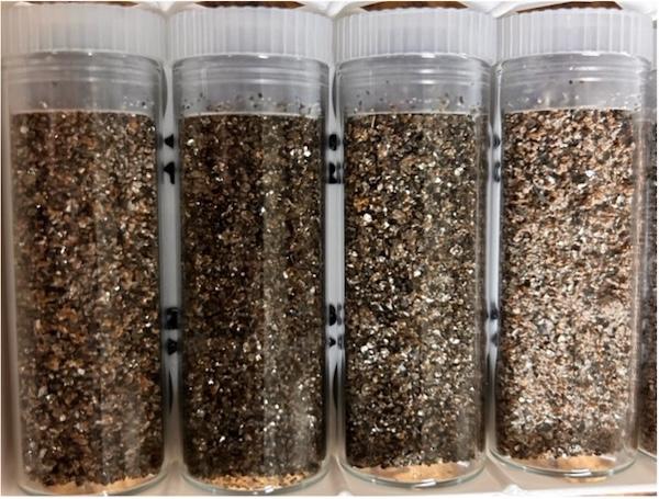
processing and organization. Since my return to the Library in July, I have been making my way through the back logged inventory of chip samples and ensuring that each well is carefully washed, vialled, and filed. In this time, I have managed to fully process over 20 wells and ensure their safe passage from the totes which they were received into their final spots within the filing cabinets. Figure 1. Rock chip samples vialled post wash and dry The proper intake and handling of core chip samples involves much more than just pouring part of the
sample into the vial and calling it a day. To correctly store and manage the chip samples that arrive at the OGSR, there is a long list of steps which our technicians must follow. When a set of samples is delivered to our facility, an employee must fill out the appropriate invoicing slips with the needed information such as depths being provided, operator name, license number, etc. Once the slip is filled out, a copy is given to the relevant operator for their records, and a copy is kept with
the samples to ensure they are not mixed up. The samples must then undergo a full screening by a geological technician where in the tech will fill out a complete sample log and document every sample bag with its depth so that each component is adequately accounted for and can be reliably found. Once the bags are organized into an accurate sequence, a portion of the sample within each bag is then transferred to a sieve which will be fed through our machine for washing and drying. At this stage,
each sample will have no information associated with it and therefore must be kept within its designated spot in the sequence so that it can be identified. Once the sieves of sample are washed and dried, they are then siphoned into a series of vials which will be marked individually to reflect the samples depth and index number. After all samples have been properly vialed and labelled, they are then finally able to be placed into the next available slot within the chip sample catalogue for
future observation. A card containing the relevant well information will be placed into the filing cabinet to accompany the sample along with a sticker on the front of the tray containing the sample to allow for easy and convenient identification. At this
time, I have approximately 6 wells left to undergo this full treatment before all backlogged inventory is completed. Upon completion, I will have processed nearly 30 wells and vialled over 5100 samples in less than 6 months. These wells have ranged from having less than 100 samples to nearly 400 and have displayed a wide range of lithological diversity. Figure 2. New OGSR sleeves filled and placed in filing tray In an effort to advance our filling system, we have switched to printing our vial filling sleeves in house this summer. A new sleeve design has been created by Jordan Clark to replace our traditional cardboard sleeves,
allowing us to fabricate sleeves on demand and in a more cost-efficient manner. In tandem with my other tasks, I have over-seen the physical printing of these sleeves as I prepare the vials which will fill them. As of now, we have printed roughly 394 sleeves, filling approximately 22 trays. These sleeves provide enough housing for around 5,122 vials. These sleeves not only provide a more cost-efficient product which can be produced on demand but are also engineered specifically to save space and
facilitate an easier and more enjoyable viewing experience for geologists. The streamlined design allows for an approximate 12% increase in storage space for each tray while also securely hugging each vial to prevent rolling or falling out. Small viewing windows are located at the top and bottom of the sleeves so that viewers may quickly scan depths and lithologies. These windows also allow for viewers to more easily pull vials from the sleeve. So far, we have seen only positive impacts from
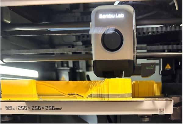
this recent switch. Figure 3. Model layer in the process of being printed In addition to flying through the inventory, I have also focused on overseeing the printing and assembly of our new Southern Ontario models. These sleek new 3D prints display a to scale model of the different lithological rock packages of
Southern Ontario according to the geological time scale. Complete with a CN Tower etched into the side of the bottom most layer, this model provides an interactive experience which allows for viewers to gain a better understanding of how the ground beneath our feet is truly shaped and structured. These models are being shipped out to universities across the country for instructive use but may also be purchased at our facilities for those keen to have a display that is both aesthetically pleasing
and functional. |
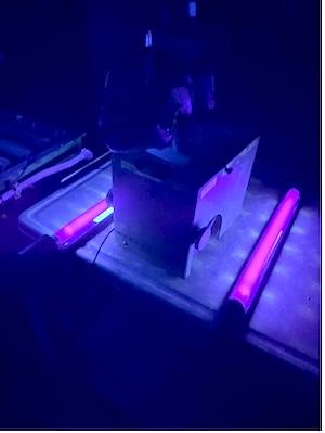
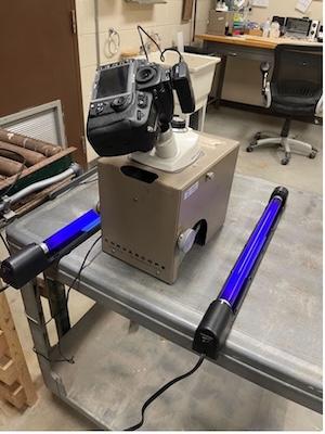
Housed within our library, the core lab provides an environment for viewing, analyzing, and documenting core and chip samples relevant to ongoing exploration, environmental studies, and academic projects. When photographic records are needed, our photo lab supports research by offering custom core and chip photography services. Our lab can provide custom rock core photos under both white light and ultraviolet light. Chip photography under ultraviolet light can be a useful step in recording the presence of hydrocarbons in cores and chip samples and locating fluid contacts within a reservoir. Clients can work with library staff to select samples, discuss project objectives, and request additional procedures such as applying chemicals to help reveal
hydrocarbons that may be trapped within the rock pores. When taking a UV photo, we use a long exposure setting and a custom white balance to maximize the quality of the photo. After the images are successfully taken, they are processed to the clients liking by cropping or adjusting exposure before being delivered to clients. This service allows clients to examine sections of core remotely or enhance their project with detailed photographic records. Whether clients are investigating reservoir characteristics, examining stratigraphic features, or conducting comparative geological research, our UV chip photography service enables integration of high-quality fluorescence imagery directly into your project workflow. We’re proud to support our clients through the photo lab and help them move their research and
exploration goals forward. |
Streamlining Chip Sample Photography |
Over this past summer the OGSR Library has been working on
improving the quality of our chip sample photography. We have done this by first creating new custom chip sample trays inserts. These new inserts are made in-house using 3D printing, and are designed to fit the exact size of the chip sample vials. This new design holds the vials in a secure position so that they can’t roll around anymore in the trays. You can pick up the new chip sample sleeves safely without risking the vials dropping due to better, more supportive material used over the
previous cardboard, which would bend under the weight of the vials. Being able to move the sleeves is an improvement for chip sample photography because you can now move a group of vials that you are currently on closer to the camera setup, remove and put back vials properly without having to go back and forth from the tray. Designing the chip sample tray inserts using 3D modelling has made it so that more vials can fit in each tray, improving our overall chip sample storage capacity when
compared to our previous setup. Next, the second way the OGSR Library has improved the quality of our chip sample photography is our development of custom chip sample photos. Custom chip sample photos allow the client to choose the licence, depth, features, and magnification of the photos, allowing the client to tailor the photos exactly for their project or research needs. Clients can also
choose the camera and type of chip sample photo they would like to take. They can choose between our standard microscope camera attached to a computer setup, attaching a professional camera to a microscope setup, or our UV light setup (as shown in Brian's article). This allows the client the freedom to further tailor their chip sample photos in a way that benefits their project or research by emphasizing characteristics of the chip sample that the standardized chip sample photo collection setup
might not show. |
Monthly Drilling Report - September 2025 Reporting of new
activity to the end of the month, including past activities reported for the first time in the month by OGSR Library Team |
New Licences Issued for Existing Wells |
Licence No. | TD Date | Operator | County | Township | Status | TD (m) | T012818A | 2025-07-31 | Quinte Energy Storage Center
Inc. | Lennox/ Addington | Richmond | STR/ABD | 899.70 |
|
Licence No. | Plug Date | Operator | County | Township | Status | TD (m) | T011286 | 2025-07-30 | Lambton Area Industries Ltd. | Lambton | Enniskillen | HOP/ABD | | T011288 | 2025-07-30 | Lambton Area Industries Ltd. | Lambton | Enniskillen | HOP/ABD | | T011290 | 2025-07-30 | Lambton Area Industries
Ltd. | Lambton | Enniskillen | HOP/ABD | | T012785 | 2025-08-29 | Landowner | Elgin | Bayham | DH/ABD | | T012818A | 2025-08-28 | Quinte Energy Storage Center
Inc. | Lennox/ Addington | Richmond | STR/ABD | 899.70 | T012820 | 2025-07-30 | Sofsurfaces | Lambton | Enniskillen | HOP/ABD | 152.40 |
|
If you are having trouble viewing this newsletter, it can be viewed here. What is the OGSR
Library? The Oil, Gas & Salt Resources Library is a not-for-profit corporation that manages all of Ontario's public drilling and production data from the petroleum and solution mined salt industries. This includes processing, storing, and providing safe and convenient access to all of the industry's drill core and rock cuttings. The
Library makes as much of this data as possible available through our online portal to members all over the world. The financial support of the petroleum industry and our membership make this possible. |
|
|
|